

California Advisory Committee on Geographic Names
The purpose of the California Advisory Committee on Geographic Names (CACGN) is to provide recommendations to the U.S. Board on Geographic Names regarding California names for official use in federal publications. The California Natural Resources Agency is the CACGN executive sponsor.
The full CACGN Charter that sets forth the roles, responsibilities, and terms of engagement can be found HERE.
Assembly Bill No. 2022
On September 23, 2022, Governor Gavin Newsom signed Assembly Bill No. 2022 (Ramos) into law. Commencing on January 1, 2025, this bill requires the term “squaw” to be removed from all geographic features and place names in the state. The bill requires the Natural Resources Agency to direct the California Advisory Committee on Geographic Names to revise its existing charter to perform specified responsibilities, including notifying public agencies, as defined, of each geographic feature and place name that includes the term “squaw.” The bill requires the Committee to chose replacement names, under its discretion, and in consultation with advisory bodies, if the local governing body fails to recommend a replacement name within the allotted 180 days.
Assembly Bill No. 2022 Information and Implementation
Sq. Replacement Name Submissions Due August 6th, 2024
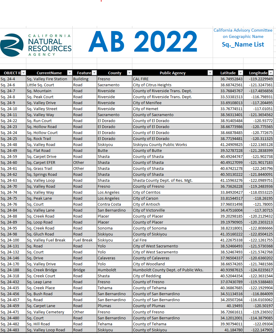
Public agencies, in partnership with California Native American tribes, must identify appropriate replacement names for the “sq_” names on features and places within the Public Agency territory. Renamed features and places should be informed by tribal consultation, public engagement with the local community, and be respectful of tribes and tribal communities. Public Agencies must submit the replacement names for all “sq_” named places and features within their jurisdiction by August 6th, 2024.
Sq Named Places and Features to be Renamed
AB 2022 Name Proposal Checklist
Some submissions were not included on this list because they have either already been changed through the secretarial order 3404, they were duplicate entries, or were not geographic features or places.
Announcement
AB 2022 Best Practices Implementation Webinar
February 16, 2024
11:00 am - 12:00 pm
Click here to view our February webinar video
Draft Assembly Bill No. 2022 Procedures
Request for public comments on the draft CACGN Procedures regarding AB 2022 implementation and tribal consultation policy by July 15, 2023. Send comments to cacgn@resources.ca.gov.
Appointed Members:
(as of 5/5/22)
Committee Members:
- Mary Simmerer, Department of Water Resources
- Daniel Walsh, Department of Parks and Recreation
- Richard Lis, Department of Fish and Wildlife (Chair)
- Amy Loseth, Department of Conservation
- Tiffany Meyer, Department of Forestry and Fire Protection
- Raymond Hitchcock, Native American Heritage Commission
- Greg Lucas, California State Library
- Susan Anderson, California African American Museum
Federal Advisors:
- Drew Decker, United States Geological Survey
- Somer Shaw, United States Bureau of Land Management
- Jeffery Ferguson, National Oceanic and Atmospheric Administration
- Rich Spradling, United States Forest Service
- Amanda Kaplan, National Park Service
Ex-Officio Members (non-voting):
- Amar Azucena Cid, Department of Transportation
- Assemblymember James C. Ramos, Select Committee on Native American Affairs
- Reginald Byron Jones-Sawyer, Sr., Legislative Black Caucus
- Assemblymember Luz Rivas, Latino Legislative Caucus
- Assemblymember Ash Kalra, Asian Pacific Islander Legislative Caucus
- Senator Susan Eggman, Legislative LGBTQ Caucus
- Designee TBD, Legislative Women’s Caucus
- Christina Snider, Secretary of Tribal Affairs to the Governor
- Geneva E. B. Thompson, The California Natural Resources Agency, Deputy Secretary for Tribal Affairs
Emeritus Advisors (non-voting):
- Jim Trumbly, former Chair, retired State Parks
- Will Patterson, past member, California Department of Fish and Wildlife
- Clayton Guiraud, past member, Department of Water Resources
- Carol Ostergren, past member, United States Geological Survey